Sunday, August 28, 2016

Back to Normandy: Jumièges


Let's go back to France for a bit. There's still so much I haven't shared yet. I love history, and I hope you do, too. One of our excursions while on the river cruise was the Normandy Abbey Route. We visited two abbeys, one a ruin and one still operating. This post is about the ruin. 


The first monastery was built here in 642. Mind-boggling. A few centuries later, however, the Vikings came a-rampaging and destroyed the monastery. 


It didn't take too long before the Vikings themselves converted to Christianity and began building their own monasteries. Duke William of Normandy, aka William the Conqueror, aka King William of England, attended the consecration of the newly constructed abbey in 1067.

The towers still stand, reaching into the blue, blue sky. Our guide pointed out how different they are - deliberate asymmetry.  


Jumièges was an important place of learning in medieval times, and was also well-known for caring for the poor. 


Some of the early paint colours can still be seen in the vaults and arches. 


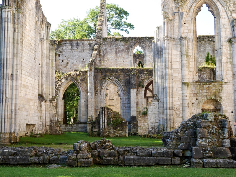
How lovely it was to wander freely through these ruins, to imagine the life of the monks, to stretch my neck back to see the tops of the ruins. 

Alas, the Abbey became a victim of religion - in the 16th century, the Huguenots destroyed much of the abbey. It was partially rebuilt, but after the French Revolution, destroyed once more. 


These are some of the beautiful details, mostly reproductions, seen in and around the abbey.


The Abbey was sold in the 19th century to a Frenchman who used the old buildings as a quarry, selling off the stones and bricks. This horrified others, who managed to purchase the site before it was totally decimated.


As with most buildings, renovations were carried out over the centuries. These two windows are probably the oldest there.


The grounds are extensive and peaceful for walking. It's preserved now as an historic site, as are other abbeys in the area. If you go to Normandy, take the time to visit one of the abbeys and take a tour. We were so glad we did. 


This pretty house sits outside the abbey walls and I couldn't resist taking a photo. Doesn't it look like something from a fairy tale? 

Linking with Mosaic Monday, hosted by Maggie of Normandy Life. 

Thursday, August 25, 2016

Road Trip - It's a Long One!


It's a long way from Victoria to Red Deer. 1198.2 kilometres (744.5 miles). I thought you might be interested in the sights along the way - it's such a pretty drive. We'll be touring in one direction, east to west, but the photos are taken both from our trip out and our trip back, so if you know the road, the angles will be mixed up. Lighting differs as well. So pack your bags, include some drinks and snacks, and we'll be off! 

We like to get a bit of a head start, so we cross over to the mainland on the ferry the night before and stay at my parents' place in Chilliwack.


Early the next morning, we quietly sneak out of the house and begin the drive. Dawn just begins to break over the mountains. We have snacks and drinks in the car. It will take us 11 or 12 hours, with a few breaks.


We begin in the Fraser Valley, a fertile delta plain where my roots began. My siblings and parents, although they moved away for many years, are all back in the Valley. Steep mountains shelter the valley, and it is to those mountains that we steer. 


We pass Mount Cheam, seen here from the east (and in the evening). Each time we pass it, I marvel that I once stood on the very top - I'd like to do that hike again some day.


Very soon we are in the mountains, taking the #5 Highway up over the Coquihalla Pass. These peaks are part of the Coast Mountain Range. Beautiful glaciers can still be seen, shining in the summer light. 


There's plenty of traffic on the highway: big trucks, tourists with their 5th-wheel trailers, motor homes, camper vans, and regular family cars. Some of them really slow down on the long, steep climbs. We climb from sea level to 1244 metres (4081 feet) in a little over an hour. 


The Coquihalla Highway is relatively new - just 30 years old. For part of the route, it follows old cattle trails and later oil and gas pipelines, installed in the 1950s. My father worked on those pipelines. The scenery is stunning as the road weaves through the mountains, along and across the Coquihalla and then the Coldwater Rivers.


After a couple of hours we come to the Interior Plateau. This is arid country, where cattle ranches flourish and thousands of lakes lie cool and blue in the landscape. 


Down into the small town of Merritt, where country music flourishes, and up again before descending into the town of Kamloops, situated at the confluence of the North and South Thompson Rivers. I spent my childhood here and swam in that cold, fast river.

We like to stop in Kamloops at the Starbucks on the eastern edge of town. We walk around the shopping center parking lot (it's only 8 am so the stores are still closed), sipping a cup of tea and munching on a breakfast sandwich. It's good to stretch our legs.


Back into the car again and we wind our way into the Shushwap and Okanagan Highlands. Shushwap Lake is a mecca for holiday-ers. Ski boats and houseboats dot the lake. It's enormous and there's plenty of room for all. 


Now we face the Columbia Mountain Ranges, of which there are four - the Caribou, the Cascades, the Monashee, and Selkirk Mountains. When I drive these roads, I marvel at the tenacity of the explorers who found the passes through wave after wave of mountains to forge transportation routes that are still used today. We go over the Rogers Pass (1330 m) and the Kicking Horse Pass (1627 m). 


We stop in Golden for lunch - a picnic, so we can get out and walk around again. Here we've descended a little and are in the Rocky Mountain Trench separating the Columbia Mountains from the Rocky Mountains.


A few wild summer flowers are blooming, but most have gone to seed.


A curious squirrel crosses the path ahead of us several times before dashing down beside the river to hide in the rocks.


Cold, cold glacier-fed water, milky from the glacial sediment.


The railway was built long before the highway and is a unifying symbol across the country. 


On our way home, we stopped, not in Golden, but at the Kicking Horse River rest area. Three rafts passed by as we watched. I hope to go river rafting one day. Have you ever done it?

The road at the bottom right of the photo is the old highway. We walked along it for about a kilometre or two. The bridge above is the new highway, and if you look carefully, you'll see the scale indicated by the tiny bumps of vehicles going over it. Called the Park Bridge, it was completed in 2007 and rises 90 metres above the river. The bridge, and its long approaches, replace the most dangerous part of the old highway, which averaged 140 accidents per year. 


Up into the Rocky Mountains we climb. We're about halfway there now. We pass through snow sheds and see warning signs to not stop in certain sections for fear of avalanches (in the winter). We see gun emplacements where experts shoot down the threatened avalanches. It's a hot day and there's no snow nearby so we don't concern ourselves with that.


A yellow helicopter hovers over a construction sight high on the mountain. Tim took this photo while I drove. We later saw it loading up again on a landing near the highway, preparing to make another drop.


Now we come to the Rocky Mountains, home to Banff National Park - Canada's first national park. Next year is the centennial of the park's opening, and as a celebration, all national park fees will be waived. 


We see a bear and some deer along the road. As we drive out of the mountains, they become less treed and more rocky.


This is Castle Mountain, aptly named, don't you think?


A storm brewed above us, but except for a few splats, it passed us by. Or perhaps we passed it. 


Wildlife overpasses allow the animals living here to safely cross the highways, which are otherwise fenced for their protection.


Just a few more hours on the level prairies where the landscape stretches as far as the eye can see and the sky looks immense.

We arrive in time for a late supper with Tim's sister - we meet at a restaurant since she wasn't expecting us until later. It feels good to crawl into bed that night, although my mind still felt it was driving. 

And in less than a week, we'll do the reverse! 

Thank you for your thoughts and prayers for Tim's mother. She is doing very well and has moved from the hospital into a transition home. She will soon be returning to her own apartment complex. 


Tuesday, August 23, 2016

Party Time!


On one of the hottest days of the summer, we planned a garden party. My brother and sister-in-law offered their garden and borrowed enough canvas shelters that we were not sitting in the direct sun.

China and glassware, pretty napkins, 


and flowers from the garden added to the festivities.  


A special Battenberg lace tablecloth looked extra pretty. We ate - grilled meat and lots of salads, we sweated gently and tried to stay cool, we laughed and chatted. 


Our talented daughter-in-law created this beautiful and delicious cake. 


The focus of the party - my beautiful mother. Thirty-two of us gathered to celebrate her 80th birthday. 


Hooray for our wonderful mother, grandmother, and great-grandmother! My dad instigated the planning for the party back in February and it all came together well. 


Before the party, a photo of four generations: My mom, the eldest daughter, Yours Truly, also an eldest daughter, my two daughters, and Miss S. We are so blessed. 


And so ended our last week of vacation - a trip to Alberta to see Tim's family there, and then a couple of days in Chilliwack for my mom's party. After cleaning up, we headed to the ferry terminal and sailed westward, into the sunset, and home again.

Since then I've been working in the garden, dealing with green beans and tomatoes, and trying not to think about school beginning next week (preparation week for teachers). The summer has flown by so very quickly.  

Sunday, August 21, 2016

A Gentry Estate in Wales


It's really hard to grasp that one month ago we were in Wales. A lot has happened since then and our trip seems a little distant already. There are many sites I've not yet shared here, and it's a great memory-jogger when I do. 

So let's visit Llanerchaeron - my cousin told me that the pronunciation of the "Ll" is like saying an "L" with the tongue towards the front palate and letting air pass on both sides of the mouth. Try it - I think it's a little bit like a "CL" sound. Correct me if I'm wrong.

While going through my photos, I realized that I did not take a photo of the outside of this Georgian villa, designed by John Nash in 1795. Nash later went on to design Buckingham Palace, Regent Street, and Brighton Pavilion. So I took the above photo from the Llanerchaeron site 


Nash was all about symmetry. The dining room is to the left of the front door in the top photo. The sideboard at the back of this photo is the front of the house. You'll notice there's no window on that wall in the dining room. But there is one outside. It's fake, just there for symmetry. 


Llanerchaeron is a small estate, as estates go. Ten generations of the Lewis/Lewes family. It's been well preserved and displays the self-sufficiency of an estate more than any other site we've seen. 

The wash-basin stand in the photo above looks as though it was created especially for the curve of the wall.


In the enormous kitchen, this dresser of china caught my eye with the blue and white. Teresa, my cousin, told me that this is Burleigh Ware, made in England from Devon and Cornwall clay. I went onto the Burleigh site after arriving home and am now thinking that Burleigh Ware may be in my future. 

There's a great article on the site that tells how to achieve the "Dresser Look". 


A focal point of any kitchen is the stove - this one is massive. I can't imagine the heat it would generate on a hot day like the one when we visited. 

The house where the family lived is not particularly large and the supports needed for such an estate are much more expansive. We saw the stables, the coach house, the cow barn and pig sties, complete with animals. 

After touring the living quarters and kitchen, we visited the cellar where beer was stored for the staff, and wine for the family. There were laundry rooms, servants sleeping quarters, a cheese room, salting room, scullery, baking kitchen and more. It really gave a picture into the "upstairs-downstairs" aspect of life for decades before the First World War. Such an estate provided work and sustenance for a large community of people.  


The walled garden was especially interesting. Within the micro-climate created by the high stone walls, food and flowers were grown to last the year. Several years ago we watched the BBC production The Victorian Garden that documented each month of the garden. It was so interesting to see such a garden, once neglected, now being brought back to life. 

Isn't the door pretty - all those coats of paint add so much character. 


Signs asked visitors to be careful about closing the doors to the garden as the farmyard animals were not welcome there.


The glass house held geraniums and other tender plants, including tomatoes. 


Roses adorn various outbuildings and small offices. 


Roses and brick or stone walls make a wonderful pair. 

Llanerchaeron gave such a complete picture of life on a small estate. We thoroughly enjoyed ourselves. 

Linking to Mosaic Monday, hosted by Maggie of Normandy Life. 

A Bit of This and That

  Off in the distance Mount Baker, in the USA, gleams in the sunlight. My best guess is that it's about 100 km away as the crow flies. T...